The El Niño Rapid Response Campaign: Monitoring the 2015-2016 El Niño from the land, sea, and air
This is a guest post by Dr. Amy Solomon and Dr. Gil Compo of the NOAA Earth System Research Laboratory and the Cooperative Institute for Research in Environmental Sciences of the University of Colorado-Boulder. Both scientists sit within the Physical Sciences Division, which took on a leading role in the El Niño Rapid Response Campaign. They excel at improving our process-based understanding of the models and developing reanalysis datasets, which are critical to understanding and predicting weather and climate.
The ongoing El Niño of 2015-2016 is a historically strong event, the likes of which is only seen once or twice during a scientific career. Not wanting to let this opportunity pass by, scientists from NOAA and NASA have embarked on an unprecedented and exciting mission to observe this El Niño like no other El Niño has been observed before! From January to March 2016, scientists have been collecting data in a notoriously data-sparse region of the Pacific via Gulfstream jets, high-tech unmanned aircraft, ship cruises, weather balloon launches, and instruments dropped right out of aircraft. This effort is known as the El Niño Rapid Response campaign.
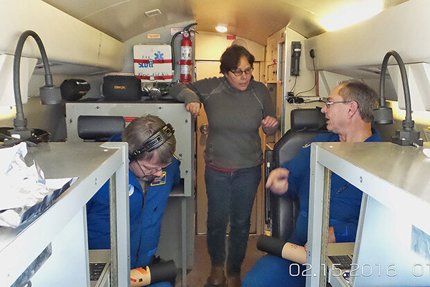
Amy Solomon and two crewmen on NOAA's Gulfstream, discuss dropsondes. Photo credit: Lisa Darby (NOAA).
The deluge that wasn’t
Why study this El Niño? As discussed in detail in previous blog entries, one significant way El Niño impacts the global climate is through changes in atmospheric wave forcing and large-scale circulations like the Walker Circulation and Hadley Circulation, which then shift the pathways taken by storms around the world. During the 1997-1998 El Niño, the North Pacific stormtrack was shifted southeastward, directing moisture-carrying storms toward California. This caused 13.68 inches of rain to fall in downtown Los Angeles in 1998—the wettest February since records began 130 years before.
There was, therefore, significant concern about the impact of the next big El Niño on California precipitation. By standard measures, the 2015-2016 El Niño has been tied with 1997-98 as the warmest El Niño in the instrumental record. However, only 0.79 inches of rainfall fell during February 2016 in downtown Los Angeles. To date, March 2016 rainfall totals are also significantly below average.
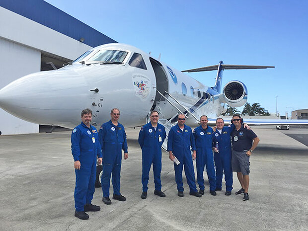
The NOAA Gulfstream aircraft which flew 23 research missions during ENRR and its crew. Photo credit: Ryan Spackman, STC.
Ok, so the impacts of no two El Niños are the same. But why?
The first link that connects the tropical Pacific to California precipitation is the development of strong thunderstorms over the warmest waters. Thunderstorms are a primary agent for exchanging heat from the Earth's surface to the atmosphere above. The second link is the response of the atmospheric circulation to the organized thunderstorm activity. This involves the response of the large-scale overturning circulation (e.g. the Hadley Cell), which determines the location of the dry, sinking air masses in the subtropics and the edge of the subtropical stormtrack.
The exact location of that edge, which is occupied by the storm-steering subtropical jet stream, has a big influence on what part of the West Coast gets soaked in any given winter. To forecast this variability, weather and climate models need to be able to simulate not only the individual thunderstorm clusters in the tropics, but also how those thunderstorms affect the entire atmosphere around them.
But for models, problems exist from the get-go. The data available on the current state of the atmosphere to start or “initialize” the model is simply not good enough, especially in the Pacific Ocean. After all, in the tropical Pacific, there are not a lot of observations. And satellites can help only so much (1).
The unmanned drone the Global Hawk, which has the ability to travel for 24 hours at a time without refueling. Photo credit: Gijs de Boer (CU/NOAA).
All hands on deck!
How can scientists improve the atmospheric models? After a suppressed Atlantic Hurricane season heavily influenced by El Niño, scientists at NOAA’s Earth System Research Laboratory Physical Sciences Division used resources that NOAA had allocated for hurricane observations to instead launch the El Niño Rapid Response campaign to monitor El Niño and its impacts on California precipitation.
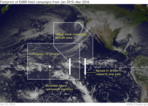
Areas covered by the Global Hawk, Gulfstream-IV, and the Ronald S. Brown research ship during the 2016 El Nino field campaign. Figure by Climate.gov from data by Ryan Spackman.
The El Niño Rapid Response campaign coordinated observations collected from aircraft (both piloted and unmanned), a ship, and from remote islands in the Pacific:
- 23 research flights with the NOAA Gulfstream-IV (G-IV) aircraft out of Honolulu, Hawaii with a suite of meteorological sensors, and deployed dropsondes (instruments that are literally dropped out airplanes to gather data) from mid-January to mid-March.
- Twice-a-day radiosonde (as opposed to instruments dropped out of airplanes, radiosondes have their instruments strapped to large balloons) launches on Kiritimati (Christmas) Island, approximately 1,340 miles south of Honolulu from late January through March.
- 8-times daily radiosonde launches from the NOAA Research Ship Ronald H. Brown while on a cruise from mid-February to mid-March to check out a buoy system already in place across the Pacific, the Tropical Atmosphere Ocean (TAO). (A tricky responsibility, especially in high winds.)
Three 24-hour research flights with the NASA Global Hawk (an unmanned aircraft that can travel for 24 hours straight at high-altitude) in February.
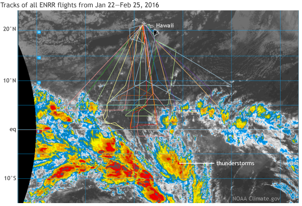
Twice a day, scientists in Boulder, Colorado, at the NOAA Earth System Research Laboratory Physical Sciences Division, met to brief the Gulfstream team in Hawaii on where to deploy dropsondes. The focus of the Gulfstream flights was to circle massive thunderstorm systems in the central and eastern tropical Pacific north of the equator to measure how air spreads out at the top of the thunderstorms. Down the line, this can influence where storms track in the mid-latitudes.
Tracks of all 23 research flights with the NOAA Gulfstream-IV aircraft out of Honolulu, Hawaii during the El Niño Rapid Response campaign from January - March 2016. Research flights were meant to circle massive thunderstorm systems in the central and eastern tropical Pacific Ocean. An example GOES satellite image from February 25, 2016 is shown to give an example of the location and scale of the thunderstorms. Conditions varied daily. NOAA Climate.gov image based off image courtsey of Matt Newmann (CU/CIRES and NOAA/ESRL) and NASA.
Were these new observations actually useful?
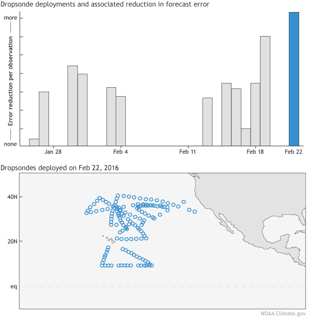
Yes! For the period of the field campaign, NASA found that for all tropical observations, the dropsondes released from the field campaign reduced the forecast error more than any other observation type. Also, the total 24-hour global forecast error in the model was substantially reduced, comparable to the total impact of the tropical radiosonde network and major satellite systems.
The dropsonde observations were able to improve forecasts by reducing errors in the poorly observed tropical eastern Pacific. This is an indication that the additional information provided by the dropsondes will improve the skill of forecasting El Niño teleconnections.
Now that the campaign is over, the observations that were taken will be used to identify model biases that limit the skill of forecasting West Coast precipitation events over the Jan-March period. Also, we’ll study how improving the initial state of the atmosphere in the models during El Niño can impact forecast skill. The campaign was an invaluable experience to test hypotheses of tropical-extratropical interactions that determine precipitation along the west coast of the US in real time.
(Top) Impact of dropsondes on the 24-hr forecast error of moist total energy in NASA'S GEOS-5 model. The error in moist total energy takes into account errors in wind, temperature, specific humidity and surface pressure. (Bottom) Location of the dropsondes released on February 22, 2016, by the NOAA Gulfstream aircraft and additional aircraft aiding in the research campaign including the unmanned drone, the Global Hawk. The release of dropsondes during the El Nino Rapid Response Campaign helped to reduce forecast errors by reducing errors in the sparsely observed tropical eastern Pacific Ocean. Bar graph data is courtesy of NASA and the dropsonde plot is courtesy of the Environmental Modeling Center within the National Center for Environmental Prediction. Figure is adapted from original provided by Amy Solomon.
Acknowledgements:
Robin Webb (NOAA), Randy Dole (NOAA), and Ryan Spackman (STC) led the ENRR campaign. Marty Hoerling (NOAA) led the twice-daily briefings at NOAA/ESRL/PSD, during which many scientists made contributions on current conditions and forecasts. Ron Gelaro (NASA) and NASA/GMAO provided the results on the observational impacts from GEOS-5 adjoint simulations. NCEP provided the maps of ENRR observations.
Lead reviewer: Tom Di Liberto
References:
http://www.latimes.com/local/california/la-me-0822-el-nino-1997-20150822-story.html
http://www.cnrfc.noaa.gov/rainfall_data.php
http://www.esrl.noaa.gov/psd/enso/enso.description.html
http://www.esrl.noaa.gov/psd/enso/rapid_response
http://gmao.gsfc.nasa.gov/forecasts/systems/fp/obs_impact/
http://www.emc.ncep.noaa.gov/cmb/stokes/enrr
Gelaro, R. and Zhu Y. 2009. Examination of observation impacts derived from observing system experiments (OSEs) and adjoint models. Tellus 61A, 179–193.
Footnotes
(1) For example, outgoing long wave radiation indicates cloud top temperature but cannot be used to identify whether this cloud cover is within a convective cell or the result of anvil outflow. Also, atmospheric winds cannot be estimated from satellite in clear sky.

Comments
. Radiosonde from Kiritimati! In 1962 Air Force
RE: . Radiosonde from Kiritimati! In 1962 Air Force
This illustrates how sophisticated weather data collection tools are used both for military and for peaceful knowledge-pursuing research purposes. Two very important parts of the human condition, each of which requires nvestment of time and resources, and high intelligence.
Add new comment