The Story for Spring: Drought Relief Not Likely
NOAA’s Climate Prediction Center released its Spring Outlook on March 21. The big story for the upcoming spring: relief for many drought-stricken areas of the United States is not likely.
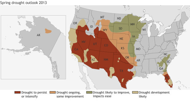
The map above shows the drought outlook for March 21 through June 30, 2013. Areas where drought is likely to persist or worsen are shown in reddish-brown. Areas of tan indicate where drought is likely to see some improvement, and areas where drought is likely to improve and its impacts ease are shown in green. Yellow indicates places where drought conditions are likely to develop.
Although drought is expected to improve in parts of the Southeast, the western Great Lakes, and the northern Great Plains, it will likely continue to plague large parts of the south-central and southwestern United States—even expanding into parts of California, eastern Texas, and the Florida Peninsula. Some areas of the country, especially the south-central region, have experienced drought conditions for over a year. Across the Pacific, Hawaii is also experiencing varying levels of drought.
Many of these drought-stricken areas are also favored to experience above-average temperatures and below-average precipitation this spring, including the south-central and southwestern United States. The maps below show probabilities of above- or below-average temperature and precipitation in the United States for April through June 2013.
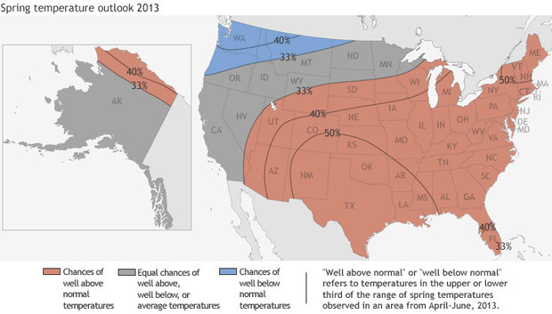
Map of 2013's spring temperature outlook.
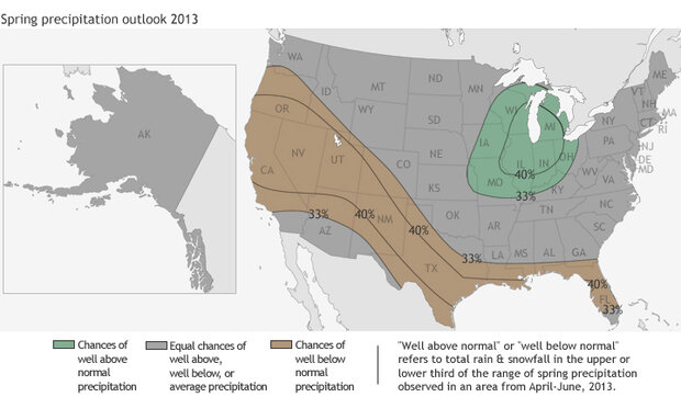
Map of 2013's spring precipitation outlook.
Locations that are likely to experience above or below average temperatures are shaded in red or blue; precipitation forecasts are shown in shades of green (well above average) and brown (well below average). Places in gray indicate areas where there is an "equal chance" forecast, which means above-, near-, or below-average temperature or precipitation are all equally likely.
In the case of these forecasts, “well above average” and “well below average” refer to temperature or precipitation in the upper or lower third of the range of climate conditions observed in an area from 1981-2010. The outlooks are more confident in some places than they are in others; the lines trace the boundaries of different levels of probability. In the video below, Deputy Director of the Climate Prediction Center, Mike Halpert, talks in more depth about the Spring 2013 Climate Outlook.
Only a small area of the continental U.S.—extending along the US-Canadian border from the Pacific Northwest and into Montana and North Dakota—is favored to see well below average temperatures. Large parts of the country have an "equal chance" precipitation forecast, but there is a tilt in the odds toward well above average precipitation in parts of the Midwest.
Related
NOAA Climate Prediction Center 3-month outlooks
Drought Impacts Continue to Pile Up
Water Waning into Winter
Baking the Breadbasket: Persistent Drought in the Heartland
Maps by NOAA Climate.gov team, based on forecasts provided by the NOAA Climate Prediction Center.
![]()


