January 2025 update: La Niña is here
La Niña conditions emerged in the tropical Pacific in December. There’s a 59% chance La Niña will persist through February–April, followed by a 60% chance of neutral conditions in March–May. Read on for the recent observations that led us to declare the (long-awaited) onset of La Niña and lots of details for current and potential upcoming conditions.
Just the facts, ma’am
A quick briefing, if you’re just joining us—La Niña is one phase of the El Niño/Southern Oscillation (ENSO), a pattern of sea surface temperature and atmospheric changes in the tropical Pacific Ocean. La Niña’s signature is cooler-than-average surface water in the east-central Equatorial Pacific, while its counterpart, El Niño, features warmer-than-average surface water. The atmospheric circulation over the tropical Pacific, called the Walker circulation, exhibits characteristic changes during La Niña and El Niño, so we call ENSO a “coupled” ocean-atmosphere system. ENSO is a seasonal phenomenon, meaning it lasts for several months in a row. The atmospheric changes of ENSO are communicated all around the world, changing temperature and rain/snow patterns in known ways.
Time to get down to brass tacks
Ok! We’ve been expecting La Niña to show up since last spring. While she’s dragged her heels, all the pieces came together this past month.
The tropical Pacific sea surface temperature loitered in ENSO-neutral since April 2024, with our primary ENSO monitoring index, the Niño-3.4 index, within 0.5 °C of the long-term average. In December, however, the Niño-3.4 index was -0.6 °C, according to the ERSSTv5, our most reliable long-term sea surface temperature dataset.
2-year history of sea surface temperatures in the Niño-3.4 region of the tropical Pacific for all La Nina events since 1950 (gray lines) and the recent (2024-25) event (purple line). After staying in neutral for most of 2024, the Niño-3.4 index passed the La Niña threshold in December 2024. Graph by Emily Becker based on monthly Niño-3.4 index data from CPC using ERSSTv5.
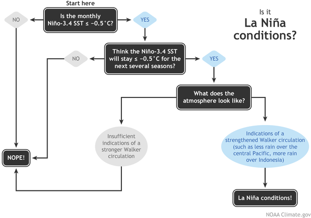
With the Niño-3.4 Index exceeding the La Niña threshold of -0.5 °C, we can move on to the second box on our flowchart—do we think the Niño-3.4 index is going to stay in La Niña territory for the next several seasons? (“Seasons” here means any 3-month-average period.) The consensus among our computer climate models is yes. Also, there is a substantial amount of cooler-than-average water under the surface of the tropical Pacific, which will provide a source for the surface over the next few months.
So, we’re on to the third box, which has actually been checked for a while now (more on that later). The atmosphere has been looking La Niña-ish for months, with stronger-than-average trade winds, more clouds and rain over Indonesia, and drier conditions over the central Pacific—all hallmarks of an amped-up Walker circulation. In December, the Equatorial Southern Oscillation Index (EQSOI), which measures the difference in surface pressure between the western and eastern Pacific, was 1.5 (positive values indicate a stronger Walker circulation). In fact, this is the 5th-strongest December EQSOI in the historical record. Drumroll… La Niña conditions have developed.
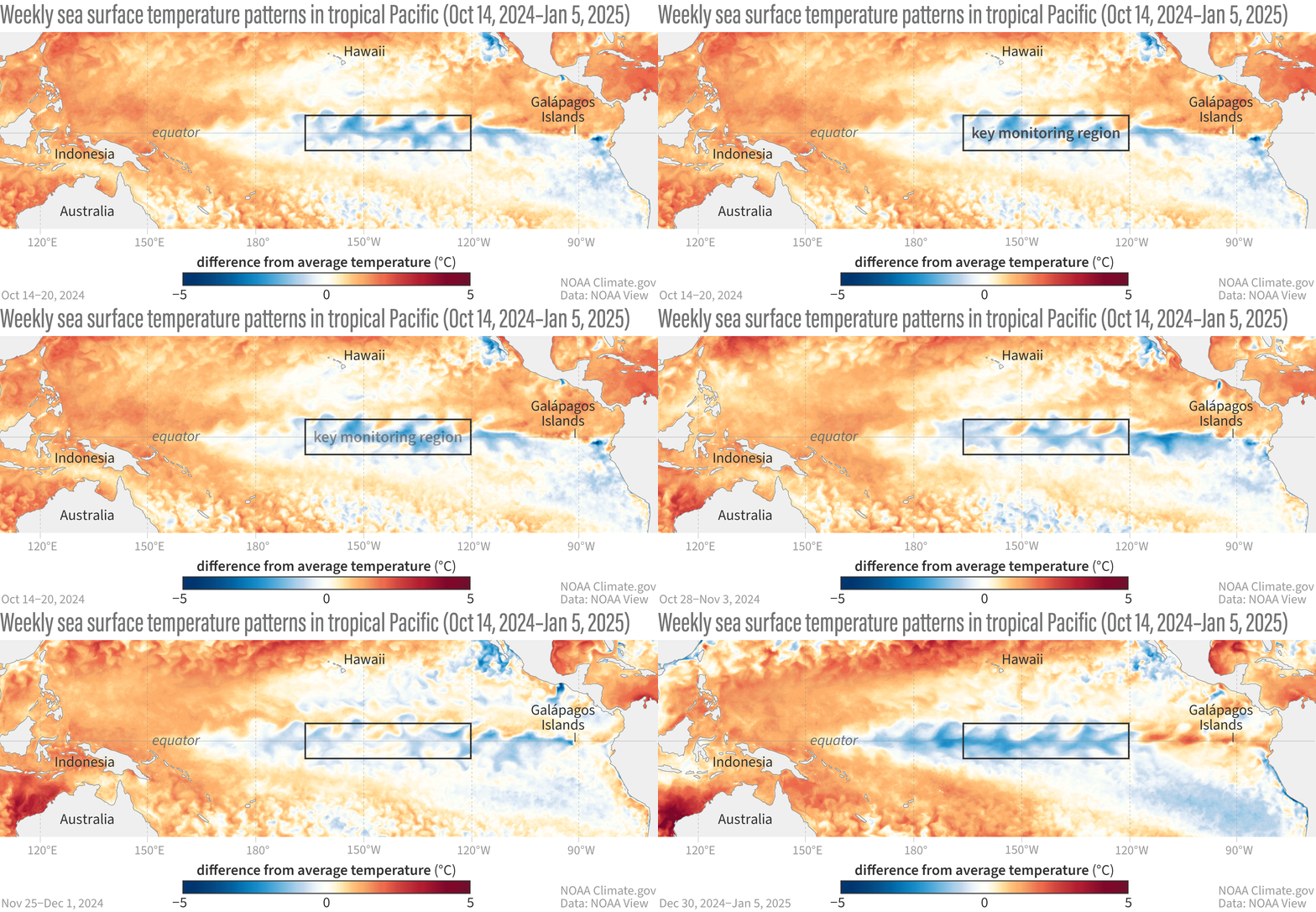
This animation shows weekly sea surface temperatures in the Pacific Ocean compared to average from October 14 2024–January 5 2025. Orange and red areas were warmer than average; blue areas were cooler than average. The sea surface temperature in the key ENSO-monitoring region of the tropical Pacific (outlined with black box) was slightly below average for many weeks, but the cooler-than-average region has strengthened lately. NOAA Climate.gov animation, based on Coral Reef Watch Data and maps from NOAA View. View the full-size version in its own browser window.
Break it down for me
There are a lot of different tidbits I want to tell you about this month, so let’s go Q&A-style.
How long will La Niña last?
There’s a reason our flowchart says “the next several seasons” instead of providing a specific number: we can make predictions, but it’s impossible to know ahead of time exactly how long La Niña conditions will last. To be categorized as a La Niña event in our historical record, the three-month-average Niño-3.4 Index (the Oceanic Niño Index) needs to stay at least 0.5 °C below average for at least five consecutive, overlapping seasons. Current odds are 60% that the March–May Oceanic Niño Index will be neutral, which would make this event last fewer than five. That’s not to say it’s impossible for this La Niña to last longer, of course—nature is always full of surprises! There is a ~40% chance for La Niña to persist into March-May 2025.
How strong will La Niña be?
It’s very likely this La Niña will be weak, with the Niño-3.4 index unlikely to reach -1.0 °C for a season. This is based on computer model guidance and how late in the year La Niña conditions emerged. ENSO events peak in the northern Hemisphere winter, and there’s just not a lot of time for La Niña to strengthen.
Can La Niña still affect our winter climate?
Sure can, although a weak La Niña tends to have a weaker influence over temperature and precipitation patterns.
Why was La Niña so slow to develop?
The short answer to this is “we don’t yet know.” The emergence of La Niña-like atmospheric conditions before substantial tropical Pacific Ocean surface cooling was unusual, though. The global oceans have been running much, much warmer than average for more than a year, which might have had a hand in La Niña’s delay. When we calculate the Niño-3.4 index but account for the temperature of the tropical oceans (the “Relative Niño-3.4 index”) we get an index that’s been in La Niña territory for months. Only this past year or so has the difference between the traditional and relative Niño-3.4 indexes been so large, and we’re still researching this new measurement and all the implications for ENSO development and impacts in a warmer world.
Has La Niña had any impact on temperature and rain patterns yet?
La Niña affects global climate primarily through atmospheric changes, and since the tropical atmosphere has been looking like La Niña for a while, this is a reasonable question! The global climate is incredibly complicated, and even a big factor like ENSO is only one player. Other climate patterns, climate change trends, and random variability can have a strong influence on overall seasonal patterns. That said, it’s interesting that the October–December 2024 temperature and rain/snow patterns over the U.S. resemble the expected patterns from previous La Niña events. See the October–December La Nina temperature and rain/snow maps, and here’s the general page if you would like to poke around.
Map showing the difference from average precipitation during October–December 2024. Green areas received more rain and snow than the 1991–2020 average, while brown areas received less. The pattern here resembles what we would expect in October–December during La Niña. Map by climate.gov from CPC data.
Temperature has a strong influence from climate trends, and the October–December 2024 temperature pattern over the U.S. is clearly dominated by more warmth.
Map showing the difference from average temperature during October–December 2024. Orange areas were warmer than the 1991–2020 average. The pattern here resembles what we would expect in October–December from combined climate trends and La Nina. Map by climate.gov from CPC data.
You’re running out of column inches. Any last tidbits?
Thanks for asking! Speaking of La Niña impacts, you might recall there’s a link between La Niña and active Atlantic hurricane seasons. In brief, La Niña reduces vertical wind shear—the difference between near-surface winds and upper-level winds—and makes it easier for hurricanes to grow. Interestingly, the August–October 2024 wind shear in the Atlantic Main Development Region (an area of the Atlantic where hurricanes tend to develop) was the weakest since 1950 (h/t NOAA’s Matt Rosencrans). We can’t say how much of it was related to La Niña, but given the relative Niño-3.4 index has been in La Niña territory for a while now, it’s an interesting situation that bears more research.
The bottom line
As this unusual La Niña progresses, we’ll be here to keep you updated on all things ENSO!


Comments
Heating source in Pacific Ocean
I have published these papers:1) Further FGGE Forecasts for Amazon Basin Rainfall the authors are Julio Buchmann, Jan Paegle, Lawrence Buja and Robert E. Dickinson at Monthly Weather Review in 1989 2) The Dynamical Basis of Regional Motion Fields Sourrounding Located Tropical Heating the authors are Julio Buchmann, Lawrence E. Buja, Julia Nogues-Paegle and Jan Paegle at the Journal of Climate in 1995.
La Nina
Unfortunately for California and the brutal wildfires we are experiencing, La does look like it has affected our winter pattern and January precipitation looks bleak right now. I am already starting to think about ENSO next year. Too long a lead time with the models for any reliance. But if we went with the CFSv2 at this time we are looking at ENSO neutral year next year. I can't remember the last time we've had one of those and haven't had many over the last decade. Just think about the contributors here for once talking about how much ENSO is not going to factor into weather.
It has been a while, for…
It has been a while, for sure. 2019–2020 was a neutral winter, but that's the only one we've had since the ENSO Blog started in 2014!
Very well written, thanks!!
Very well written, thanks!!
Date error
Fixed! Thanks.
Fixed! Thanks.
La Niña Modoki
The ONI is not over 0.5. I believe this is more a La Niña Modoki. I don’t expect to have cooling right off the coast of South America. We have a fast warming with 26C isotherm around 10-15m depth.
You're right, the most…
You're right, the most recent ONI, October–December, is only -0.4 C. We think it's very likely that the November–January ONI will pass the La Nina threshold.
NOTHING resembles any Nina…
NOTHING resembles any Nina. 100% of the tropical countries are smashing all heat records set during 2023/2024, 100% ! including all oceania and south america and including Ecuador coast (GUayaquil dec 2024 much warmer than dec 2023 and all records smashed over and over again) and all central america, the EXACT opposite of what we would expect ina Nina or even a transition.
You fail to understand teh causes because you clearly don't have an idea on what it's been going on with the current drop of the low clouds in the tropics and the reduction of the albedo. Climatology is NOT for you. Leave it to the REAL EXPERTS and not politicians who pretends to understand it.
Add new comment