A trio of drought hotspots across the United States
Details
Extremely warm temperatures across much of the United States in September and October 2016 have conspired with much lower than average precipitation in parts of the country to bring (or sustain) severe drought to three separate “hotspots” in early November.
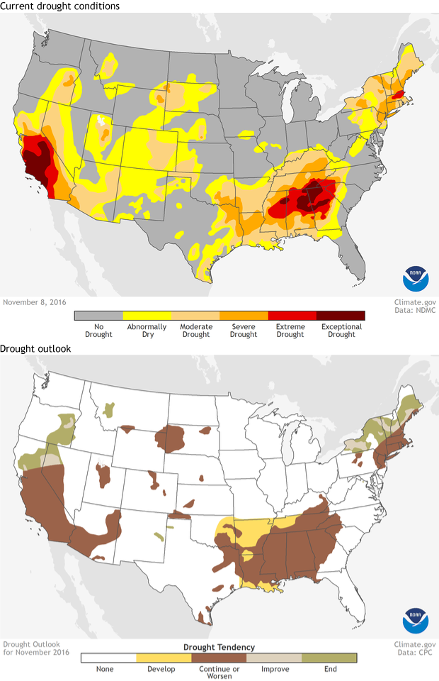
Between California—still in drought after nearly 5 years—the Southeast, and New England, 11% of the contiguous United States (i.e., the Lower 48 states) was experiencing severe, extreme, or exceptional drought as of November 8, according to the U.S. Drought Monitor project.
The maps at right show the drought status across the country as of November 8, 2016 (top), along with the outlook for the remainder of November (bottom). The large versions of the maps (links are below and to the right of the main image) show Alaska and Hawaii. Of the country’s hardest hit areas, only inland areas of New England are likely to improve throughout the month. In the Southeast and Southern California, drought-stricken areas are likely to persist or worsen and possibly expand.
Be sure to check in with our Beyond the Data blog later this week, when Deke Arndt from the National Centers for Environmental Information will be blogging about the scope and impacts of the drought in the Southeast.
These maps are part of Climate.gov’s Data Snapshots map collection, which provides popular NOAA maps in variety of sizes and formats for easy re-use and sharing.
