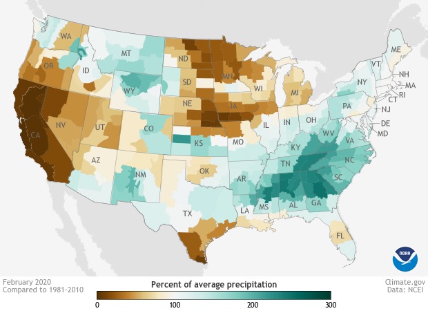
February 2020 was a month of precipitation extremes for the United States
Details
Among the highlights of the February 2020 climate summary for the United States were the precipitation extremes experienced by different parts of the country. Much of the Southeast experienced record or near-record wet conditions last month, while almost all of California and parts of Oregon and Nevada were either much drier than average or record dry.
This map shows precipitation—including both rain and snow—for February 2020 as a percent of the 1981-2020 average. Places where precipitation was close to 100% of average are white or very light yellow (just barely below normal) or very light green (just barely above normal). Dark browns and greens indicate extreme departures from average.
The February numbers brought no good news for California, which depends on winter months for the lion’s share of its annual precipitation. On the heels of a drier-than-average January, February was drier still, with many areas reporting less than 5% of their normal rainfall. Some locations in the northern part of the state received no measurable precipitation all month, setting local records for the driest February and bringing an early start to the annual fire season.
At the other extreme, an continuous arc of record to near-record wet conditions stretched from eastern Texas through the Southeast and up the Southern Appalachians to West Virginia. Among other impacts, heavy rain caused landslides in Virginia, historic flooding in Mississippi, and road closures in Alabama.
For more details about February climate conditions in the United States, visit the National Centers for Environmental Information.
